Scientists have finally confirmed the existence of Earth’s hidden eighth continent—Zealandia, or Te Riu-a-Māui—after nearly four centuries of speculation, failed expeditions, and glimpses of scattered evidence. What remained out of reach for generations was not lost in deep space but submerged beneath the Pacific Ocean, largely invisible yet vast enough to reshape our understanding of Earth’s geography.
The story of Zealandia began in 1642, when Dutch explorer Abel Tasman set out from Jakarta in search of Terra Australis, a mythical landmass believed to balance the Earth’s northern continents. As Tasman sailed west, then south, then east, he unknowingly skimmed the very edges of this hidden continent before reaching the South Island of today’s New Zealand. His encounter with the local Māori turned violent within days, and he retreated without ever stepping onto the land he hoped would be a commercial paradise. Though convinced he had found part of the great southern continent, he failed to recognize what truly lay beneath his ship.
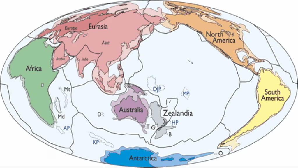
Centuries later, scientists have delivered the confirmation Tasman could never obtain. In 2017, geologists at New Zealand’s research institute GNS Science announced that Zealandia is indeed a continent—a 4.9-million-sq-km landmass, nearly six times the size of Madagascar. Yet 94% of it lies underwater, with only New Zealand, New Caledonia, and a few specks of Australian territory rising above the surface.
Geologist Andy Tulloch describes the revelation as a reminder that “something obvious can hide in plain sight for a very long time.” Zealandia had done exactly that. Its geology was difficult to sample, its boundaries impossible to see without modern satellite gravity mapping, and its features too spread out for early scientists to connect.
Hints began to surface in the 19th century when Scottish naturalist James Hector studied islands south of New Zealand and concluded they were remnants of a much larger drowned landmass. But with no scientific definition of a “continent” at the time, his insight faded into obscurity. Not until the 1960s did geologists establish criteria—thick continental crust, geological diversity, and significant size—that could finally give Zealandia a framework.
Even then, interest remained low because mapping a submerged continent required immense funding. That changed when the United Nations Convention on the Law of the Sea allowed countries to expand maritime territories by proving the presence of extended continental shelves. For New Zealand, demonstrating that it sat atop a continent suddenly became an economic incentive. Funding surged, scientific voyages returned, and rocks, sediments, and seismic profiles slowly exposed the truth.
Satellite gravity maps eventually revealed Zealandia as a misshapen, distinct mass almost as large as Australia, settling the question with an image that textbooks could no longer ignore.
The formation of Zealandia is just as fascinating as its rediscovery. It once formed part of the ancient supercontinent Gondwana about 550 million years ago, joined to eastern Australia and a large portion of West Antarctica. Around 105 million years ago, tectonic forces stretched Zealandia’s crust so dramatically that it thinned to nearly half the depth of a normal continent. Its weakened structure gradually sank beneath the ocean, yet it retained the geological identity of continental crust—granite, schist, limestone, and ancient metamorphic rocks unlike the basaltic crust of the ocean floor.
Scientists still debate how Zealandia managed to stay intact despite its unusual thinness. They also continue to investigate whether most of it was ever above sea level. While today only a few ridges rise above the Pacific, evidence suggests that its land level has changed dramatically over millions of years. Some studies propose that much of Zealandia might have plunged underwater about 25 million years ago, only to be uplifted again by tectonic interactions between the Pacific and Australian plates.
Those shifting landscapes raise compelling biological questions. Fossils discovered in New Zealand in the 1990s—including sauropod bones, ankylosaur remains, and the foot bone of a large predatory dinosaur found in the Chatham Islands—suggest that land animals lived there long after Zealandia separated from Gondwana. Yet whether these species roamed across a vast connected land or survived on isolated island refuges remains contested.
The continent’s story deepens with its modern wildlife. The flightless kiwi, for example, shares an unexpected lineage with Madagascar’s giant elephant bird rather than with New Zealand’s extinct moa. This connection hints that Gondwana’s breakup scattered ancient bird ancestors across the globe, leaving genetic breadcrumbs on fragments like Zealandia.
In 2017, the International Ocean Discovery Program drilled over a kilometer into the seabed at several Zealandia sites. The cores revealed pollen, spores, and microfossils from shallow, warm seas—clues that parts of the continent were once near sea level and possibly exposed. These tiny fossils serve as a time capsule, suggesting Zealandia’s environmental history is far more dynamic than previously believed.
Geologists are just beginning to unravel these mysteries. Zealandia’s shape remains especially puzzling. Its geological belts twist sharply along the line where the Pacific and Australian plates collide, as if the entire lower half of the continent has rotated away from the upper section. Scientists agree that tectonic forces caused this dramatic kink, but the exact mechanism and timing remain major unanswered questions.
Exploring such a continent is slow, costly, and technically demanding. Much of Zealandia lies two kilometers underwater, and the geological layers scientists need to sample sit hundreds of meters beneath the seabed. As Rupert Sutherland of Victoria University of Wellington explains, “This continent isn’t hiding its secrets out of malice—it’s simply extremely hard to reach.”
Yet Zealandia’s discovery proves that Earth still holds extraordinary surprises. Nearly 400 years after Abel Tasman sailed through these waters, the world continues to uncover revelations that redraw our maps and deepen our connection to the planet’s ancient past. The eighth continent, once dismissed as legend, is now an accepted piece of Earth’s geological story—and one of its greatest scientific puzzles.

Meera works full-time as a UX designer in Bengaluru. She writes part-time for the platform, sharing insights on smartphone launches, digital trends, and user-focused tech. Her passion lies in helping readers understand tech in a simpler, more human way.